

By Micheal Rose | PressPoint News
NEW YORK — The United Nations General Assembly has overwhelmingly backed a resolution promoting a new world map designed to present the size of Africa and other continents more accurately.
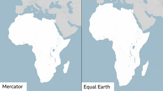
The resolution, spearheaded by Togo and supported by African countries, seeks to move away from the widely used Mercator projection, which significantly exaggerates the apparent size of landmasses located farther from the equator while making Africa and other equatorial regions appear smaller than their actual land area.
The resolution was approved by 164 countries, with six abstentions and only the United States voting against it, according to reports of Friday’s vote.
The proposal promotes the use of the Equal Earth projection, a map design developed in 2018 that provides a more proportionate visual representation of the world's land areas.
The development has attracted global attention because of the striking differences between the traditional Mercator projection and maps that preserve relative land area.
Under the Mercator projection, Africa can appear comparable in size to Greenland. In reality, however, Africa is about 14 times larger than Greenland. The distortion occurs because the Mercator system enlarges regions as they move towards the poles, making places such as Europe and North America appear disproportionately large compared with countries closer to the equator.
Togo led the initiative on behalf of the African Union, arguing that the way the world is represented on maps can influence how people perceive the relative importance and size of different regions.
Togo's Foreign Minister, Robert Dussey, described the campaign as an effort to ensure that geographical representations better reflect scientific reality, rather than perpetuating longstanding distortions.
The initiative is part of the broader #CorrectTheMap campaign, which has received backing from the African Union and seeks greater use of area-accurate map projections in schools, institutions and digital platforms.
Africa’s Map Gets Bigger — But Its Territory Has Not Changed
Despite descriptions circulating online that the UN has voted to “make Africa bigger” while “shrinking Europe and North America,” the resolution does not change the physical size, borders or territorial boundaries of any continent.
Instead, the change concerns cartographic representation — how the three-dimensional Earth is displayed on a two-dimensional map.
The Equal Earth projection makes Africa look substantially larger relative to Europe and North America because it reduces the distortion found in the Mercator projection. The land itself, of course, remains exactly the same size.
Mercator Map Will Not Disappear Completely
The UN resolution is also not legally binding and does not ban the Mercator projection.
Mercator remains particularly useful for navigation because it preserves angles and directions in ways that make it valuable for maritime and aerial navigation.
Instead, the resolution encourages governments, educational institutions, international organisations and technology companies to consider more geographically accurate projections for general maps, education and public communication.
Togo has already indicated plans to introduce the new approach into its school geography materials before the end of the year, while discussions are expected to continue with other African countries, international organisations and technology companies involved in mapping and location services.
The United States, which was the only country to vote against the resolution, reportedly criticised the initiative as promoting an ideological agenda and argued that the issue distracted from more pressing global challenges.
The vote nevertheless marks a significant symbolic victory for African countries campaigning for a more accurate representation of the continent and could influence how world geography is taught and displayed in classrooms and digital platforms in the years ahead.
PressPoint News
Get the story. Get the point.


0 Comments
No comments yet. Be the first to share your thoughts.
Leave a Comment